Gaia GPS Smartphone App
Superb backcountry GPS app
We all use GPS to navigate urban areas. But what about the backcountry? If you’re skilled with map and compass, you can, under favorable circumstances, determine your point position. But if it’s dark, you don’t recognize any landscape features, or you’re in heavy forest cover, you’re probably out of luck. As a wilderness navigation instructor (and former Forest Service ranger), I’ve tested over a dozen backcountry GPS apps, and for me Gaia comes out on top. I have used this app for about three years. It enables me to travel with increased confidence and safety in the back country when hiking and mountaineering. Here’s why it’s great:
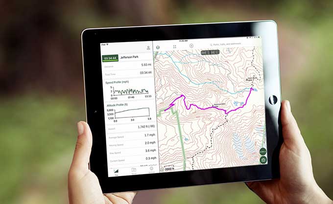
- A quality GPS app offers the holy Grail of navigation: a highly detailed map with a “you are here” marker on your exact location. Gaia has the complete functionality of a “normal” GPS: mark waypoints, record tracks, generate routes, show compass, show distance and bearing to a waypoint, download quality basemaps, and easily share this information with others.
- It has a (mostly) intuitive interface without much extra fluff (like posting your hike statistics to social media.)
- Gaia works in airplane mode (which is a great battery saver) and outside cell phone range. Download base maps via wifi (faster) or over cell network for use when you’re outside cell phone range.
- Superb customer support. Gaia has a dedicated support staff who will usually get back with most any question you have within a day or two. How many apps can say that?
- Regular upgrades. In May 2017 Gaia released a major update. This has a cleaner interface, a “snap to trail” feature which is a great help in making routes, additional base maps, faster map rendering, and more.
- Terrific base maps. Many GPS hiking apps give you one or a just a few options for underlying base maps. Gaia gives you dozens, and with the pro version, you can layer one on top of the other, for example a satellite image and a topo contour map. Open source mapping gives street, topographic and cycling coverage for the entire world, so the app works great for international travel.
While you can probably figure out the core functions of the app on your own, there are some good YouTube videos that can get you up to speed in a few minutes. (At present, Gaia works better on the iPhone than Android, but the Gaia development team is apparently working hard on an improved Android version.)
Standalone GPS units (like from Garmin) have some major drawbacks – they cost several hundred hundred dollars, have a poor user interface and screen resolution, and have limited and often expensive base maps. Since I put Gaia on my iPhone a few years ago, I have not once taken my Garmin on a hike or mountaineering trip.
The iPhone uses both the US GPS satellite constellation and the Russian GLONASS system, so receiving satellite signals even in canyons or under tree cover has improved greatly in the last few years. (On a recent multi-day trip on the Rogue River in Southern Oregon last month, Gaia consistently found my exact position in a narrow river canyon in under 20 seconds.)
There are a few downsides to phone based backcountry GPS: Battery life, fragility, and the lack of a dedicated GPS antenna. You should always carry a small auxiliary battery and charging table, and consider a sturdy case for your phone if you’re really going to beat on it outdoors. And, of course, you should always carry a paper map and know how to read it.
If you’re a “GPS power user”, and use your GPS to record tracks for all day for multiple days, or use it in very cold weather conditions, you may want to have a dedicated GPS. But for pretty much all “recreational” users, Gaia GPS on your phone should be all you’ll ever need. Gaia offers a free one-week trial to put it through its paces, and after that it’s $20 a year annual subscription. Yes, that might seem a lot for an app, but if you consider it’s quality and the cost of the alternatives, it’s still a bargain.
10/19/17Gaia GPS (Free to $30 per year, depending on features)