

Family of Five Tandem
I live near the Pacific, along highway 1, which winds along the length of California (mostly). Two days ago I was riding my bicycle along a coastal path around noon, when coming around a curve in the opposite direction was this apparition. Hey, it was a yellow tandem bike. No there’s more than two. Wait, there are kids. Little kids. Whoa! There are five people riding. Add luggage! They were obviously on long trip but they went by pretty fast, and I did not have a camera. So I googled them. Found their blog.

Their story is even more amazing. With gear their bike weights 600 pounds. They’ve ridden 4,000 miles so far and are headed up the coast to Alaska. They left their home in Kentucky with $300 in their pockets.
I rode my bicycle across the country once so I know what is involved and man, those kids must be amazing.
According to their facebook account, they are scheduled to cross the Golden Gate Bridge today at 10 am. That would be a photo opp.
The Rippies, New Yippies on the Right

Salon ran a very insightful article on the rise of the new yippies on the right: Glenn Beck is the new Abbie Hoffman. It’s very prescient. The author suggests that like the radical yippies in the 1960s, today’s radicals endorse a similar list of tactics, behaviors, and beliefs. Today’s Right Hippies (Rippies?) follow radicalism, Luddism, anti-science stance, street theatre (or more like broadcast theater), and dropping out (a 60s hippie term). I would add another indicator to their list: The homeschooling movement, which also encourages families to dropout from the public education system. Finally, a favorite book of the rippies is Saul Alinsky’s Rules for Radicals. In October, 2008 an analysis by V. Krebs of Amazon book recommendations, where customers who bought book A, also bought book B, showed that Rules for Radicals was highly correlated with the purchase of other conservative books.
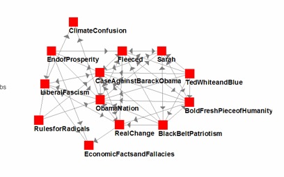
Rules for Radicals in the lower left.
The tea partiers are the hippies of our time. True, they tend to be relatively affluent — but so were the hippies. As Tony Hendra once told me, “You had to have a lot of money to take part in the Summer of Love.”
Consider the following countercultural features of the emerging American right:
Anti-System Radicalism: Just as the New Left claimed that the New Deal era wasn’t really liberal, so the countercultural right claims that the Republican Party from Nixon to George W. Bush wasn’t really conservative. ’60s radicals like Carl Oglesby denounced John F. Kennedy and Lyndon Johnson as sinister “corporate liberals” in the same way that the radicals of the right claim that the two Bushes, if not the sainted Reagan, were inauthentic “big government conservatives.” The radical left had Ralph Nader. The radical right has Ron Paul.
Luddism: A few decades ago it was the countercultural left that opposed science, technology and markets. Now mainstream environmentalists have arguably gone too far in adopting the market rhetoric of cap-and-trade. Stewart Brand, the founder of the Whole Earth Catalog, today seeks to save the environment by means of nuclear power plants, genetically modified crops and urban living.
Nowadays anti-science, anti-technology Luddites are more likely to be found on the right, among opponents of stem-cell research and evolutionary biology. And while the exaggerations and cover-ups of some scientific proponents of global warming undermine the claim that science on this subject is settled, it is clear that many conservatives reflexively believe the opposite of what progressives say on this and other subjects. If Al Gore changed his mind and announced that global cooling was imminent, one suspects many on the countercultural right would immediately warn of rising global temperatures and flooded coastlines. A counterculture inverts not only the widely-shared values but also the agreed-upon facts of the dominant culture they despise.
Street Theater: The eclipse of the countercultural left by the countercultural right is evident in political protest as well. Carnivalesque protest is practically monopolized by the tea-party right in the age of Obama. In the U.S., at least, the street theater of antiwar and anti-World Bank activists cannot compete with the mass demonstrations of the tea partiers. The giant puppets of the left are out. Posters of Obama with a Hitler mustache are in.
Dropping Out: In a letter to other conservative activists in 1999, the late Paul Weyrich, the president of the Free Congress Foundation, called on the right to adopt an explicitly countercultural strategy. “I no longer believe that there is a moral majority,” Weyrich wrote. “I do not believe that a majority of Americans actually shares our values.”
Echoing the back-to-the-land hippies of the ’60s and ’70s left, Weyrich called on conservatives to secede from American society and form their own subcultural communities. “And while I’m not suggesting that we all become Amish or move to Idaho, I do think that we have to look at what we can do to separate ourselves from this hostile culture.” Weyrich concluded by holding up the countercultural left as a model for the new countercultural right: “The radicals of the 1960s had three slogans: turn on, tune in, drop out. I suggest that we adopt a modified version.”
Portal to the Id: World Weekly News

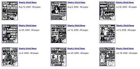
I don’t care what you say, the World Weekly News was an awesome publication. Like the Men in Black said, you get to hear about alien landings months in advance of any other source. I subscribed to it for years. I had it mailed to my office at Wired. I read it because it had the greatest headlines EVER. Before the web, it was the the single best portal into wonderful weirdness, obscure insanity, the cultural id, urban legends, and the gestalt of our times. Now entire decades of its epic awesome back issues are available for free
here.


Proverbs for the Future
Anne Herbert was a gifted writer who edited CoEvolution Quarterly (the periodic magazine of the Whole Earth Catalog) before I did in the early 1980s. We never worked together, or were close friends, but I really dug her writing. It was telegraphic, lyrical, abbreviated, evocative, extremely personal and mystical. She wrote in short bursts. Like proverbs from a secret bible. Brian Eno noticed her stuff works really well on t-shirts. It was not like any writing I had encountered. (She came up with the phrase “practice random kindness and senseless acts of beauty” which later became a meme.) Readers loved her; but publishers did not get her.
After one book of her work that sank on the marketplace, she disappeared in the mid 1980s and never published again even in magazines. I often wondered about her. She was decades ahead of her time. I always thought her stuff was perfect for blogs and twitter. But after 1990 no one I knew had seen her.
Recently I discovered that she is still going, still writing and that she has a weekly blog! In fact she has been blogging since 2005! I’ve been reading her online recently although she doesn’t know it. She’s as good as ever. She is the epitome blog/twitter writer IMHO. It turned out she had been broadcasting 140 character tweets and bursty blog postings long before either media existed.
I love her sensibility. You might too.
Some recent samples. These are not cut or edited. These are the entire entry.
Do less; have less; be more.
***
Flawedness is the only option. I disagree, but there it is. I don’t know how to deal with flawedness in myself or others. Now, that’s a flaw.
***
Music fans are more likely than musicians to love the kind of music they love and disdain other kinds.
Musicians are more likely to love music as a group and to be riveted by at least one kind of music their fans feel is wrong, so very wrong.
***
Renata Adler was a New York Times movie critic who brought to the job the gift of not being particularly fond of movies as an art form. She almost didn’t like them as a group.
This gave her access to general insights less available to lovers of the form.
She said you can’t make an anti-war movie because film always says yes to what it shows.
****
Sometimes the people who invent things and the people who find out what things are for are different people.
***
Someone who has been deeply wounded must be deeply healed.
***
I twist myself into a pretzel to believe the story, the official story of some group I like, to stay inside a “we” I want. Not much nutritional value.
***
I might have to cry for a hundred thousand years. Or maybe an accurate laugh would do some of the same work.
***
While I’m thinking about this problem, what is the part I am skittering away from?
***
All that room inside a minute, all those seconds, hundredths of a second. All those nanoseconds, and here comes another minute, moving and spacious.
Remix of Out of Control
The other day I got a note from a Danish guy who is a fan of my book OUT OF CONTROL. He found my ideas great but my presentation “frustrating.” But unlike my other “frustrated” readers, Andreas Lloyd decided to do something about it: he remixed my book!
I think the result is quite amazing. Remixing is perhaps too strong a word because he mostly simply dropped entire chapters, with a little re-arranging here and there. It is a very sharp but intelligent edit. But the effect is striking. Instead of a rambling book about one dozen things, Lloyd’s remix of my book focuses it on the cybernetic and feedback aspects of the systems I was reporting on in the early 1990s. I suggested this focus needed a better title than OUT OF CONTROL, which I never was happy with anyhow, so Lloyd came up with a new one for this version of the book. He calls it BOOTSTRAPPING COMPLEXITY.

So if you never read OUT OF CONTROL because you were put off my its length, here is a user-generated remix that shortens and focuses the book. You can read it on Lloyd’s website or even download the PDF. (I will post the PDF here on kk.org as well.)
Lloyd’s notes read thus:
Kevin Kelly’s book “Out of Control” is a fascinating book full of fascinating ideas reaching across the board from artificial intelligence, evolution, biology, ecology, robotics and more to explore complexity, cybernetics and self-organising systems in an accessible and engaging way.
But in reading Out of Control, I found it suffering from a number of frustrating flaws: Not only is it way too long-winded, it is also almost completely void of meta-text to help the reader understand what Kelly is trying to do with his book (having read the book, I’m still wondering).
Indeed, reading the book I got the feeling that Kelly was trying to combine several different books into one: There is a fascinating study of self-sustaining systems. But there is also a sort of business-book take on network economy. And an extended meditation on evolution and postdarwinism.
I’m sure that to Kelly, all of these things are tightly interconnected. But he doesn’t explain these interrelations very well to the reader. His central argument is that as technology becomes ever more complex, it becomes more akin to biological systems (eco-systems, vivisystems, interdependent and co-evolving organisms). But because the individual chapters are set up as essays on their own, there is often little to tie these wildly different ideas together.
I would have preferred a much shorter book, more narrowly focused on the idea of self-organising systems. The whole text of the original book is easily available online at Kelly’s own website, so I thought: Why not remix the online text to make such a book?
So I did.
However, if you liked BOOTSTRAPPING COMPLEXITY, you may also want to try my “long-winded” original version with lots more stuff. It is available as web text and a free PDF as well.
I think Lloyd is a fantastic editor, and his fan-based work is exactly the kind of liquidity of text that I believe will propel books in the next century. His remix is the kind of literary fluidity I was talking about in my Scan This Book article for the New York Times.
Oldest Living Things in The World

Besides the canonical Bristlecone Pine, there are many other organism on earth that will outlive you. Photographer Rachel Sussman has been traveling around the world to find and photograph them. I’m surprised by the number and variety of long-lived organisms. I very much like that she includes the low lifes — lichen and so forth. You can keep up with her investigations with her intelligent blog.

.
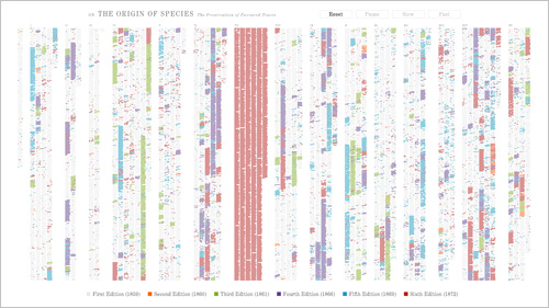
Evolution of Origin of Species
Ben Fy has visualized the evolution of Darwin’s text as he edited and updated his On the Origin of Species. Fry says:
We often think of scientific ideas, such as Darwin’s theory of evolution, as fixed notions that are accepted as finished. In fact, Darwin’s On the Origin of Species evolved over the course of several editions he wrote, edited, and updated during his lifetime. The first English edition was approximately 150,000 words and the sixth is a much larger 190,000 words. In the changes are refinements and shifts in ideas — whether increasing the weight of a statement, adding details, or even a change in the idea itself.
Social Media Venn
I thought there was some truth in this Venn diagram of behavioral disorders and social media. You can get the diagram on a T-shirt.

Crowdsourced 3D City
If a million monkeys typing can write Hamlet, can a million tourists’ snapshots map out a 3D picture of Rome?
The answer is yes. And Venice, too.
There are more than 2 million photos on Flickr tagged with Rome. They capture almost every nook and cranny, every column and doorway, of the old city. If you had a lot of computer power, and the right smart software, you could take these 2 million views and compile them into a single unified 3D portrait.
And if this system from the University of Washington GRAIL lab worked for Rome you could take other highly photographed places, such as St Marks Plaza in Venice, and construct a visual 3D picture, down to the smallest detail.
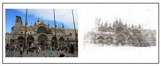
Microsoft’s Photosynth accomplished a similar feat. The movie below does that same thing with huge piles of photos taken off of Flickr.
Eventually, the every city in the world will get a full textured 3D view of itself. (via Waxy)
Very Short History of the Planet Earth
John Baez has written a Very Short History of the Planet Earth. He says, “The Earth has survived some remarkable disasters. To keep our tale brief, let us focus on four: the Big Splat about 4.55 billion years ago, the Late Heavy Bombardment about 4 billion years ago, the Oxygen Catastrophe roughly 2.5 billion years ago, and the Snowball Earth events about 850 million years ago. The details of these events — and indeed, whether they even happened at all — remain controversial. We shall present some widely accepted theories without dwelling on caveats or alternative scenarios. In every case, there is interesting physics involved in testing these theories.”
It’s not the whole history, but select dramatic parts, told simply and quick. It includes many scenes I was not aware of.

The dust cloud that is the precursor to Earth.