Along Interstate 75
Toronto to Florida road trip guide
I’ve used CAA (AAA for those in the US) maps and TripTiks for long journeys in the past. In January I went on a greatly anticipated road trip on I-75 to Florida from Toronto, ON. Though I have a GPS in the car, iPhone, and iPad, my favourite directional aid was Along Interstate 75 by Dave Hunter.
Think of it as a TripTik on steroids. Dave and his wife are into the 16th printing of the guide. They’ve not only mapped the entire route from the border at Detroit/Windsor, to the Georgia/Florida border, but they’ve made remarks about the entire route. Remarks is even an understatement. The book has a page for each 25-mile segment of the highway. Each exit has details on the gas stations, restaurants, and accommodations available.
There’s also the usual stuff one finds on maps: place names with populations, and secondary roads. But there’s so much more. Photos of architectural or agricultural or historical interest. Hints on where to eat; where the locals eat, in many cases. Descriptions of tourist spots, what to miss, what to visit. He includes what he calls “hidden gems;” a food joint, or a historical home you might miss if you’re just driving through. Great places to shop, along with places to avoid. There is also loads of historical information about the communities you drive by or through, along with interesting facts about the highway. And in many stops including the tourist information centers, restaurants, or lodging, he includes the names of the people working there.
The book is easy to follow, and perhaps best used when there’s a navigator and a driver. It kept us amused for hours and hours on the journey. We looked forward to what Dave had to say as we rode the road. We missed the book a great deal when we took another route home.
You can find out more information about the book on Dave’s website www.i75online.com. He has also written a companion to the book for inside Florida called Along Florida’s Expressways. We weren’t quite as comfortable with it, but it did go up a notch in our own rating system when we figured out that he was the only one to mention the best manatee viewing station in Florida in Ft Myers at the Lee Co. Manatee Park. None of the big name travel guides we had did that.
02/8/11Excerpt
p. 86
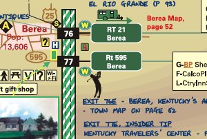
Exit 154-A Civil War Execution: Just a quarter of a mile east of this exit is an historical marker commemorating a sad Civil War event which took place in 1864. Three Confederate soldiers were brought here from the Union prison in Lexington. At this spot, the three were hanged as a reprisal for the guerrilla murder of two Union sympathizers.
*
*
p. 90
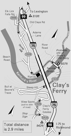
Exit 99- Clay's Ferry (not suitable for large RVs). If you're getting a bit tired of the freeway, I've got a small diversion for you. It will only take a few extra minutes- the entire distance is 2.9 miles (4.7 km). Let's go down and visit the Kentucky river and see the site of historical Clay's ferry.
Actually, there's very little to see now but the scenery is pretty and the drive interesting (don't try this if icy!). After leaving I-75 at exit 99, follow the winding road down 200 ft into the river valley. Riptide on the River- this 75-year-old restaurant on the banks of the Kentucky river has recently changed ownership.
*
(Note: Dave Hunter provides a free sample 14-page PDF that covers most of Kentucky. --OH — editors)
Along Interstate 75 Dave Hunter 2010, 208 p. $17