Day: June 25, 2012
 06/25/12
diglloyd Advanced Photography and Making Sharp Images
Understanding optics and sharpness in photography
06/25/12
Understanding optics and sharpness in photography

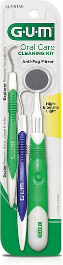
Two incredibly handy tools seldom used for their intended uses are dental mirrors (a.k.a. “inspection” mirrors) and dental picks. The one problem with most inspection mirrors is that when you have to look into awkward electronic or mechanical crevices where you need a mirror, you also need a flashlight for illumination and a spare hand to hold the light. This kit (#832) has a dental mirror with a bright flashlight integrated into the handle and a switch in the grip, freeing up your other hand. The other neat thing is that for less than $10 you get two dental picks — great for nudging or extracting small inaccessible components from assemblies. Recently, I was upgrading a friend’s computer. The motherboard was mounted in a “baby ATX” case which was a very tight fit. To locate the CMOS reset jumper or check to see if the memory socket catch was engaged, I needed the use of the lighted mirror to negotiate the dark spots where those components were hidden. In the same manner the picks were handy to snag small cables within the case. — Stephen A. Kupiec
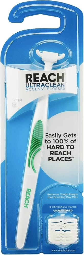
The civilized way to floss. A tiny, easily replaceable harp on the end of a stick. More hygienic (no fingers in your mouth), more effective at flossing the hard parts, more comfortable, easier to use. Our kids love ’em. I floss much more often myself since I started using one. A really cool tool more folks should use. — KK
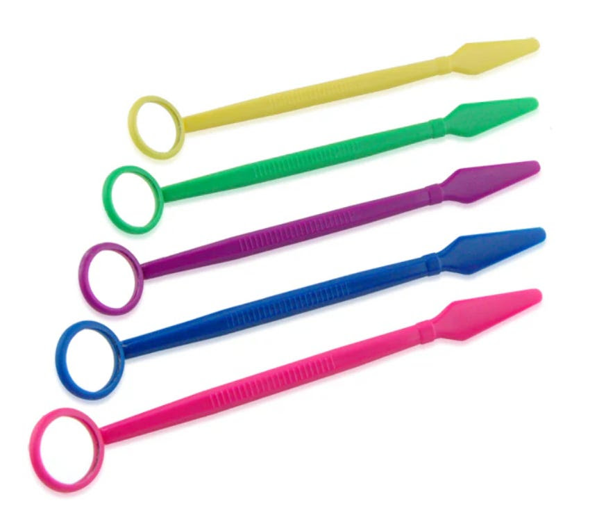
I got mine — made of surgical stainless steel — from a set of used dental tools at a garage sale for 25 cents. It’s incredibly handy for inspecting missing fillings, infections, gum complaints, particularly in kids. And you can look for sharp edges on dental braces. There really is no other way to look deep inside the mouth. The key is to get a proper front-surface mirror, which some drugstore plastic versions don’t have. Otherwise at close range there is a slight double image which confuses the image. — KK
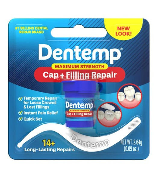
Dentemp is a traditional dental combination of zinc oxide and eugenol (clove oil) mixed when needed to make a temporary tooth patch for lost cavity filling, or to re-cement a cap or inlaid on a tooth. It’s strong enough that you’ll need to have a dentist remove it later. Since an emergency Dentemp kit weighs less than an ounce, it should be part of your traveling or backpacking kit. You can get it at almost any drug store. — KK
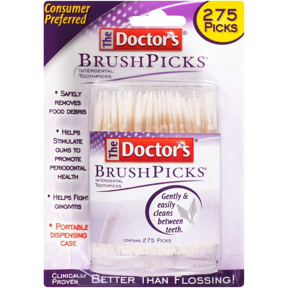
I hate flossing. I hate how the floss cuts into my fingers and lips, and how it gets wet and slimy and impossible to manipulate. I’ve tried those little flossers with handles but they’re not much better than regular floss. I’ve used interdental brushes (they’re like itty-bitty bottle brushes with handles) but they’re not flexible and don’t fit between normally-spaced teeth. After years of ignoring my dentist’s suggestion to just floss the teeth I want to keep, I think BrushPicks are my solution.
Each disposable plastic pick has a pick end and a brush end. The pick end has tiny ridges that help to scrape harder material from between your teeth. But it’s the brush end that’s a real innovation. It looks kind of like a feathery antenna, with a flat row of tiny bristles extending on either side of a thin, flexible pick. This brush end is stiff enough and thin enough to poke easily between your teeth, but flexible enough that it readily bends so that you’re not jabbing painfully into your gums. This flexibility also allows for cleaning behind rear molars. Rotating the brush end as you clean helps to loosen and remove gunk from otherwise impossible-to-reach areas.
BrushPicks are so effective that they’re actually kind of fun to use–in a “look what I just dug out of my own head” sort of way. I’ve taken to using one every 2 or 3 days and I’m anxious to see if my dental hygienist notices the difference during my next cleaning. — Rhodora Collins

There is very little chance you’ll ever be beyond the reach of a dentist most of your life. However, like its companion Where There is No Doctor, the true audience for this free PDF (and for-sale printed book) is care-givers in the developing world. But this tome also works as a short course in emergency care. Real dental first aid that is useful for anyone to know. — KK
Once a week we’ll send out a page from Cool Tools: A Catalog of Possibilities. The tools might be outdated or obsolete, and the links to them may or may not work. We present these vintage recommendations as is because the possibilities they inspire are new. Sign up here to get Tools for Possibilities a week early in your inbox.

© 2022
