Caltopo Backcountry Mapping Software
The best backcountry mapping software currently available
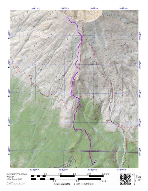
Caltopo is, in my opinion, the best backcountry mapping software currently available. The fact that it’s free and browser-based makes it even better. If you take a few minutes to learn the software, you will probably never purchase another topographic map ever again in your life.
This software is used by hikers, nordic skiers, mountain bikers, hunters, climbers, wildland firefighters, biologists, Search and Rescue (SAR) teams, and most anyone who needs a quality map of the backcountry. I’ve been using it for several years now, and it’s miles better than anything else out there, paid or free.
Here’s what you can do with Caltopo:
Make topographic maps of anywhere in the world with just a few clicks. (While it’s mostly useful in the US and Canada, the Open Cycle layer has worldwide coverage.)
Display more than a dozen different map layers, including standard topo maps, aerial imagery, shaded relief, marine charts, historical maps, standard Google map layers, and US Forest Service, to name a few.
Mix and match layers by adding new layers and changing the opacity. (One blend I like is a satellite layer, overlaid with an topo map at about 50% opacity.)
Import GPS tracks and waypoints and show them on a displayed map (very handy for backcountry travel).
Robust yet easy to use drawing features. Draw a freeform line, add a few waypoints for trailhead, campsites, etc, then export these drawn features as a .GPX file ready to use in your smartphone GPS app or GPS receiver.
Easy printing, at any scale or most any paper size you want, easy to add lat-long or UTM grid lines While the free features will be sufficient for most people, the website does have an optional subscription service.
Upgrading your subscription to a modest $20 per year gets a few things, including the ability to print on paper other than 8.5 x 11, store and share maps online, and few more whistles and bells, but most importantly, supporting the one guy who makes this site go, who up until a year or so ago ran this site entirely as a free hobby on the side. When you consider that the cost of a single large recreational map can be almost $15, paying $20 per year to keep Caltopo running is an incredible bargain. So, if you find it useful, please consider a subscription.
The interface is pretty intuitive, but there are a few tricks. YouTube has some excellent instructional videos to get you started. I have a Master’s degree in cartography, made maps professionally for many years, am a former USFS backcountry ranger, and teach wilderness navigation to hundreds of people year, so I would not recommend this unless it was terrific.
11/17/16